Safety Committee November Meeting
The Safety Committee met Monday evening. After reviewing our 2024 accomplishments and setting some goals for the future, we took an in-depth look at some ways we can improve downtown once the North Main Street bridge project is complete.
2024 Accomplishments
- At the intersection of East Orange, North, and Mill Streets vegetation was cleared to improve visibility between drivers and people entering the crosswalk. New illuminated stop and pedestrian crossing signs were installed, and – as a result of the bridge closures – an all-way stop was created.
- At the intersection of Bellview and South Main Streets the stop bar was restored to full width as Bellview is one-way eastbound at that point.
- On Washington Street across from Senlac Hills Drive two&company have installed a proper curb, driveway apron, and sidewalk along the entire frontage as part of the development of their new café, which I appreciate a great deal.
2025 Goals & Objectives
- Central Shopping Business District streetscape improvements (see below)
- Carriage Stone Sidewalk construction
2026 & Beyond
- 2026 – Add markings and signage to the Bell Street crosswalk at Vincent Street
- 2026 – Add pedestrian facilities to Vincent Street between Bell Street and the River Walk Trail
- 2027 – Complete the sidewalk at the corner of Maple Street & Solon Road (pdf)
- 2029 – Add pedestrian access to the Miles Road bridge
Central Shopping Business District Streetscape Improvements
The North Main Street Bridge construction has created a real opportunity to address the many complaints the village receives about walking downtown. The project is on track to be completed in late 2025 or early 2026, and the Safety Committee has spent the last year planning for any changes we wish to make at that time. For this meeting I prepared one-page write-ups on four topics that make great starting points for improvements: High-Visibility Crosswalk Markings, Crosswalk Daylighting, Mid-Block Narrowing, and Flashing Yellow Arrow Traffic Signal.
High-Visibility Crosswalk Markings
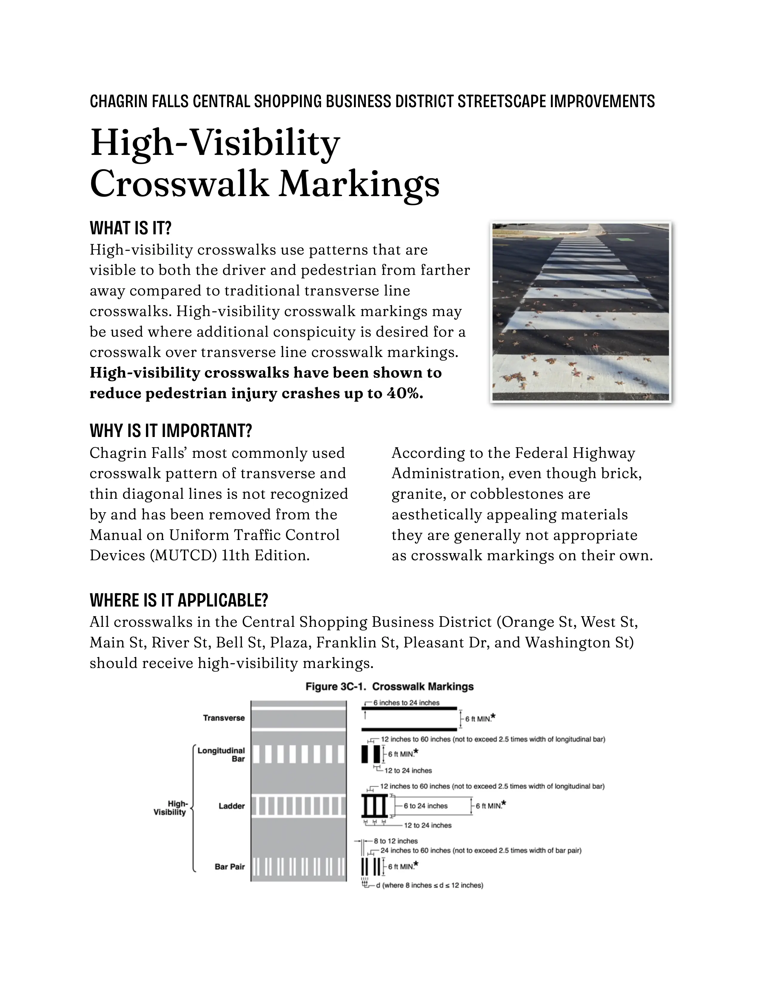
The Manual on Uniform Traffic Control Devices recognizes two types of crosswalk markings: transverse line or high visibility. Transverse markings are the white “borders” of the crosswalk that run perpendicular to vehicle travel lanes from curb to curb. High-visibility markings include additional stripes or wide bars that run parallel to vehicle traffic throughout the interior of the crosswalk. In areas with a lot of vehicle and pedestrian traffic like downtown Chagrin the Federal Highway Administration (FHWA) recommends high-visibility markings. Most crosswalks in the village are marked with transverse lines and thin, widely spaced diagonal lines which is not a high-visibility pattern.
We should adopt the longitudinal bar pattern throughout the Central Shopping Business District, and it sounded like everyone else on the committee and from the administration agreed.
Crosswalk Daylighting
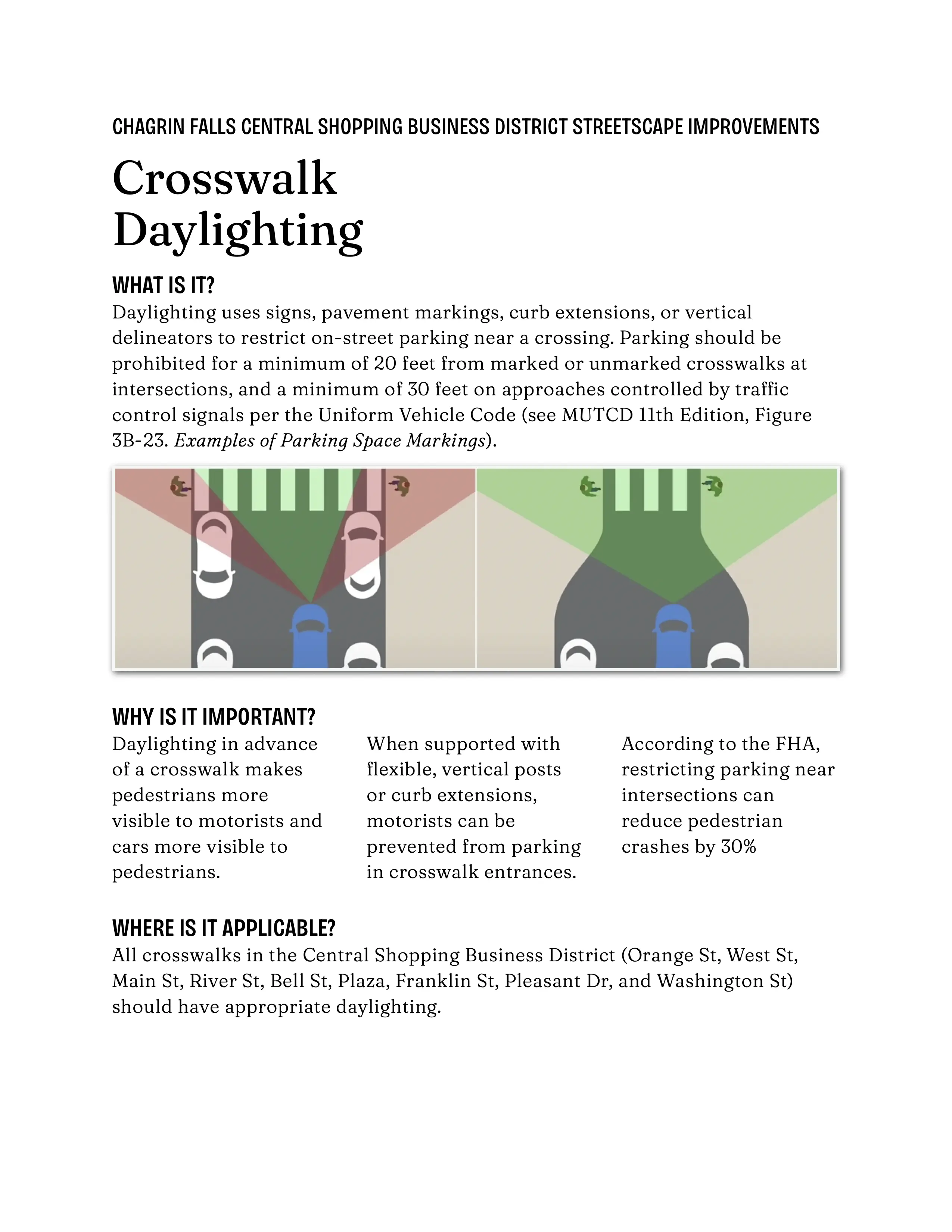
Daylighting uses signs, pavement markings, curb extensions, or vertical delineators to restrict on-street parking near a crossing, making pedestrians more visible to motorists and cars more visible to pedestrians. The FHWA recommends prohibiting parking for a minimum of 20 feet from crosswalks at all intersections and 30 feet from crosswalks at intersection that are controlled by stop signs or traffic control signals.
Earlier in the week I did a quick survey of downtown crosswalks and found that the parking restrictions are all over the place, from 0′ on most sides of the Main Street and Franklin Street mid-block crosswalks to 35′ on the southeast corner of Main Street at Bell Street. Most places fell somewhere in the middle, with 6′ to 16′ of daylighting.
We discussed the need to balance street parking with pedestrian safety, but the consensus was that daylighting should be improved. The Main Street Bridge project has made 15 to 20 spaces temporarily unavailable and the result has been fine, so taking away a few spaces to make crosswalks safer seems a reasonable tradeoff. Rob and Tim will be preparing new designs for parking – with improved daylighting at crosswalks – in advance of the downtown being repainted once the bridge project is complete.
Mid-Block Narrowing
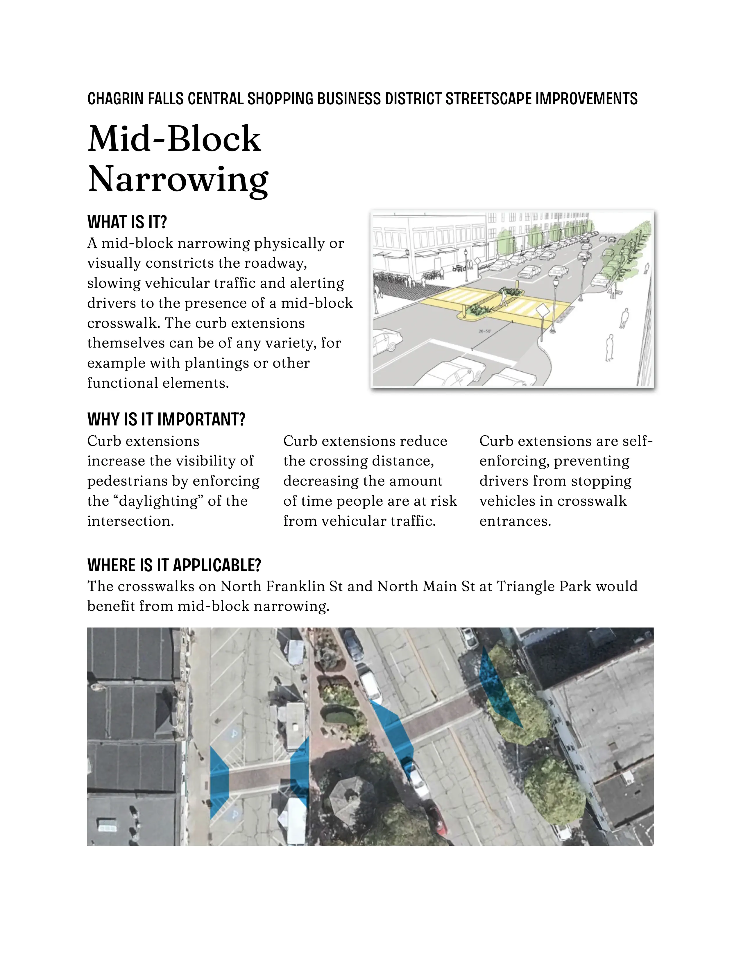
People trying to cross the street seem to have the most issues (drivers not stopping, almost being hit) at the mid-block crosswalks on Main Street and Franklin Street at Triangle Park. One way to improve mid-blocks is with a narrowing of the street by bringing the curb out from the parking lane to the travel lane. This has the benefit of increasing the visibility of pedestrians and reducing the crossing distance. I like it because it’s self-enforcing, and prevents the crosswalk entrance from being blocked by illegally stopped vehicles. The village engineer will prepare plans for curb extensions at mid-block crosswalks for the Safety Committee to review at a future meeting.
Flashing Yellow Arrow Traffic Signal
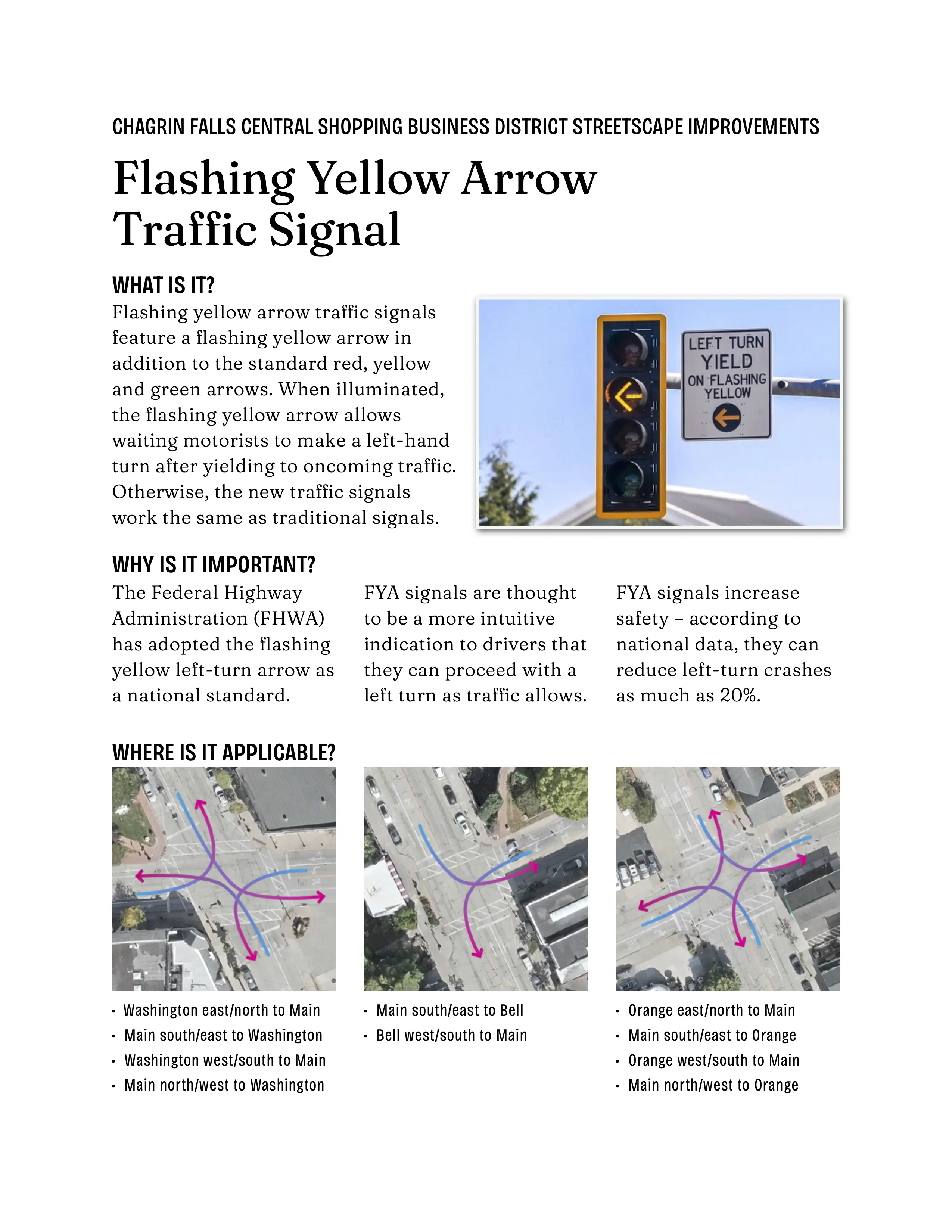
The flashing yellow arrow is a new type of signal placed over the left turn lane. A flashing yellow arrow means yield to oncoming traffic and pedestrians and then proceed with caution. It’s the FHWA’s new standard and replaces the round green light for left turns are allowed but must yield to oncoming traffic.
These were pitched as a way to make pedestrians safer when they have the walk signal and permissive left turns are also allowed, but I found some research that indicates they don’t make much of a difference in that situation (Flashing-Yellow-Arrow Research Spotlights Pedestrian Safety Risk).
After some discussion we decided a better alternative would be to prevent left turns any time the walk signal is active, to prevent people and cars from ever crossing paths. This could be accomplished either by a Protected Left Turn Phase, or an exclusive pedestrian interval (Pedestrian Scramble or Barnes Dance) where all car traffic stops and people can cross in every direction (even diagonally!). The engineers will prepare a report to estimate the level of service for both of these scenarios.
North Main Street
At this point we discussed the possibility of reducing Main Street from four lanes to three. The recently updated vehicle counts show that the volume of traffic doesn’t justify two lanes in each direction, and having only one lane each way for the bridge project hasn’t caused any significant issues. I pointed out that Main Street from Orange to Washington is the only four-lane street in Chagrin Falls, and Erinn added that it’s the only place in the entire Chagrin Falls school district. The road width is a legacy effect of the highway that used to run through the middle of town, a common situation that many other places are resolving with a Four to Three-Lane Conversion.
2025 Grant Opportunities
As always, the village will pursue any available outside project funding.
- USDOT Safe Streets and Roads for All (SS4A) Grant Program
- ODOT Transportation Alternatives Program (TAP)
- ODOT Safe Routes to School (SRTS)
Meeting Materials
- High-Visibility Crosswalk Markings (pdf)
- Crosswalk Daylighting (pdf)
- Mid-Block Narrowing (pdf)
- Flashing Yellow Arrow Traffic Signal (pdf)


